Geospatial solutions to empower location-based data
As geospatial experts, we can build you a complete solution from the ground up, update your legacy applications, or augment your team to add geospatial functionality to your application.
What We Do
Our dedicated team consists of skilled and experienced Application Developers, QA Testers, Business Analysts, UX/UI Designers, FME Certified Professionals and GIS Specialists - so you know your software will not just work well - it will also be easy to use and look great too!
Geospatial (GIS) Software Development
Full-stack development and GIS team
Collaborate with you to bring your vision to life
Seamlessly blend open source and proprietary technologies
Open-Source or Esri geospatial data, automation and management
Esri ArcGIS Solutions
Esri Gold Business Partner
Spatial analysis and geoprocessing tools to analyze relationships between complex geospatial data, reveal patterns, expose relationships between features and provide decision support
Python scripting to analyze information, automate tasks and create efficient and repeatable workflows and results for GIS processes
ArcGIS apps (Collector, Survey 123, Workforce and Operations Dashboard) to collect, manage, monitor and seamlessly integrate data into cloud-based GIS platforms
FME Solutions
Safe Software Authorized Partner and FME® Solution Provider
Integrate, transform and standardize data from over 450 formats and applications
FME services, including:
FME automated workflows(repetitive tasks, enforce validation rules and faster, more reliable access to information)
SV is a complete hosted web GIS, empowering your organization to realize the value of its spatial data
SV includes spatial editing, geoprocessing, mobile integrations and high-resolution map outputs
SV’s foundation is Esri technology and can integrate with existing geospatial data feeds and base imagery
Survey Plan QA Automation (SPQAA)
SPQAA is a hosted service, back by FME, with a customizable set of automated checks to ensure survey plan quality
SPQAA improves efficiency and reduces rework in plan creation, within your organization or with plans submitted by your clients
SPQAA can aid in plan visualization, ensuring it will integrate with the surrounding data and area as expected
We’re the Integrated End-To-End Solution Partner You’ve Been Looking For
Our Clients
Testimonials
Our clients have great things to say about Silvacom CS
I highly recommend the Silvacom CS team
They worked very hard to understand our vision and turn it into something tangible, user-friendly, and visually appealing.
Brock Mulligan
Director of Communications - Alberta Forest Products Association
Silvacom CS has been great to work with
We were looking to develop a technical solution for tracking, displaying and storing forest history photographs, stories and information. My team is not well versed in technology options; thankfully the Silvacom CS team has made the process easy while engaging our members in the analysis and review. I highly recommend Silvacom CS considering the experience their team brings to a project or initiative.
Bruce Mayer
Secretary-Treasurer - Forest History Association of Alberta
Choosing Silvacom CS proved to be the right decision for us
Silvacom’s process of design and implementation kept multiple stakeholders from several different organizations/jurisdictions well informed through the design and development of a much-needed critical infrastructure digital project that impacts us all as Albertans.
Todd Nash
Partner, Consulting Services - MNP
Silvacom CS brings great leadership and experience
We were fortunate to have Silvacom CS as our partner for over a decade on a very complex engagement. Throughout the journey, Silvacom CS' leadership around geospatial data and experience with visioning and creating a visually appealing user experience were key pieces to our joint success. Their responsiveness, flexibility and commitment to a successful outcome make Silvacom CS a great partner.
Craig Coward
Client Executive, NTT Data Services
Silvacom CS saved my sanity
We are a small municipality who were trying to get the basics of our new GIS system functioning and automated. The Silvacom team took the time to figure out where we were at in our journey and provide solutions that just worked. They have been available to answer questions and help with things since finishing the work. They were flexible and worked with us to fit our budget and timeline. I would not have been able to get our GIS system to the level it is now without them.
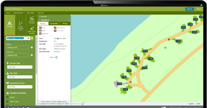
ReserveAlbertaParks.ca is an Alberta-based campsite registration and reservation system that helps friends and families get away from it all and spend time together outdoors.
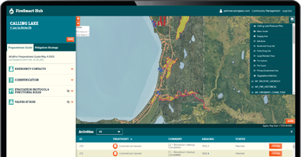
The FireSmart Hub
The FireSmart Hub is a map-centric system that enables communities to plan, create, manage and share FireSmart plans to be better protected from the risk of wildfires.
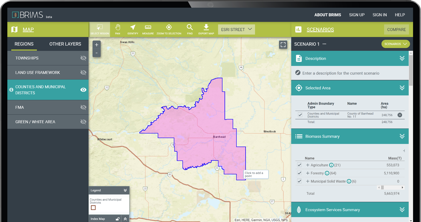
The Bio-Resource Information Management System (BRIMS)
BRIMS is a centralized location for Alberta’s bio-resources data. It connects the world to the province’s biomass and other ecosystem services through an interactive web tool where users can map, summarize and report on the data.
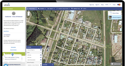
The Altalis Datastore
Altalis is Western Canada’s trusted source of spatial data, the Altalis.com datastore enables customers to explore, view and acquire spatial data products, both paid and open data with the click of a button.
We’ve Been Building Cloud-Based Solutions Since 2001